


Make sure you are compliant with all FAA regulations prior to your next launch. In this blog post, we cover all the laws and regulations that apply to Near-Space Balloons to make sure you are prepared and compliant.

High altitude balloon launches are unpredictable and constant teachers. On a recent launch in December 2019, we were reminded of a few key lessons. Learn from our mistakes!
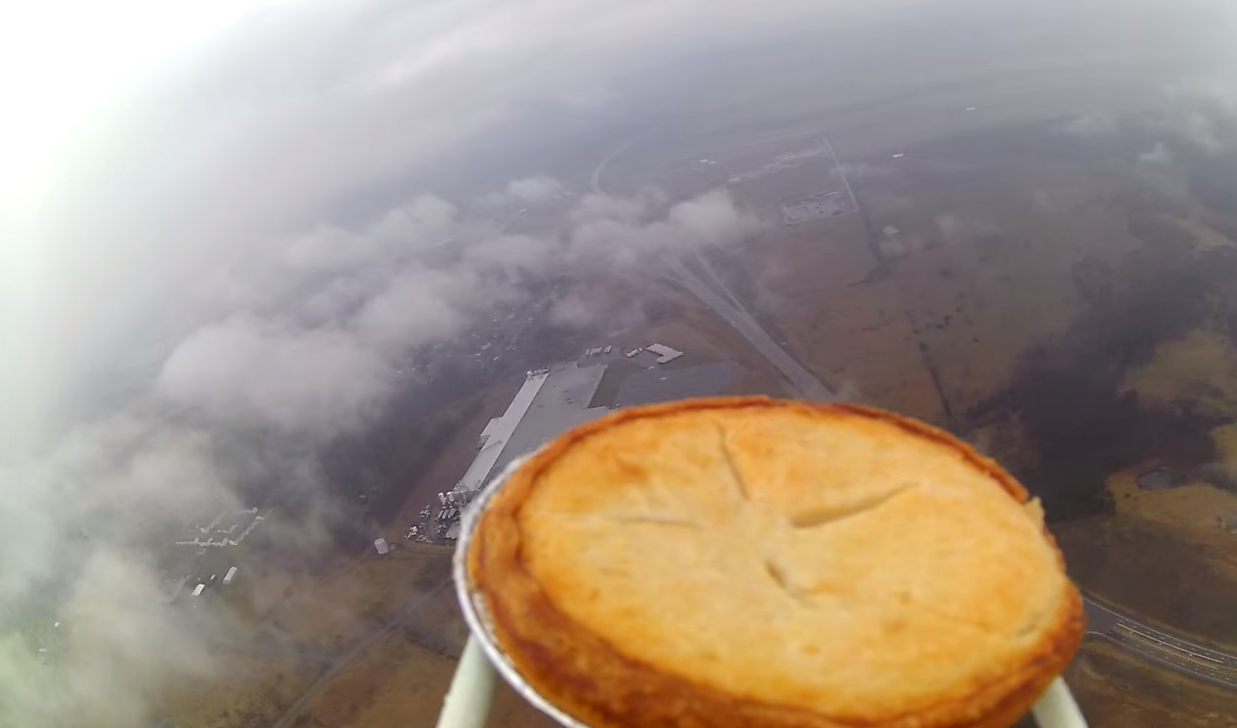
In this post, join us as we launch a test payload with our planned equipment (GoPro Camera, Colbert Platform, Astronaut Ice Cream) to ensure everything will be ready for the actual Colbert launch. Come Launch with Us!
This is the story of our launch to assist The Late Show with Stephen Colbert to send Astronaut Ice Cream to near-space for the first time!
Perhaps you recognize this post's cover photo from a recent Late Show with Stephen Colbert skit: Astronaut Ice Cream is a Lie. Indeed, that skit used Launch with Us planning and flight hardware to plan for, execute, and retrieve the space ice cream payload. To make sure that we reached our objective altitude, we had to ensure that we chose the proper launch configuration. How did we do it? More about predicting altitude is below, while more details on the story of the Colbert launch itself will be coming in the next blog posts!

During our first years of work on this project we developed what we feel to be a reliable and low cost spacecraft for High Altitude Balloon projects. In keeping with our mission, we decided to open-source the design of our “Dogeship-Class” spacecraft for anybody looking to get into this hobby but don't quite know what to purchase for their first launch.
This has been a great machine to learn with and has enough room for experiments while still being very portable and flyable. This weather balloon kit list, combined with our HAB User Guide, should get you started! Additionally, we are very open to feedback on this design - seasoned veterans, we want to hear from you!
The links provided in the list (2019 list here) are all to Amazon.com and use the 'Amazon Associate' program. If you decide to purchase some or all of this material, we kindly ask that you use the links below. You pay the same price you normally would, but we get a small percentage of Amazon's normal fee as a referral bonus. Any proceeds from this will help to keep this website and resources free and available to everyone!
Base Spacecraft Requirements (~$110)

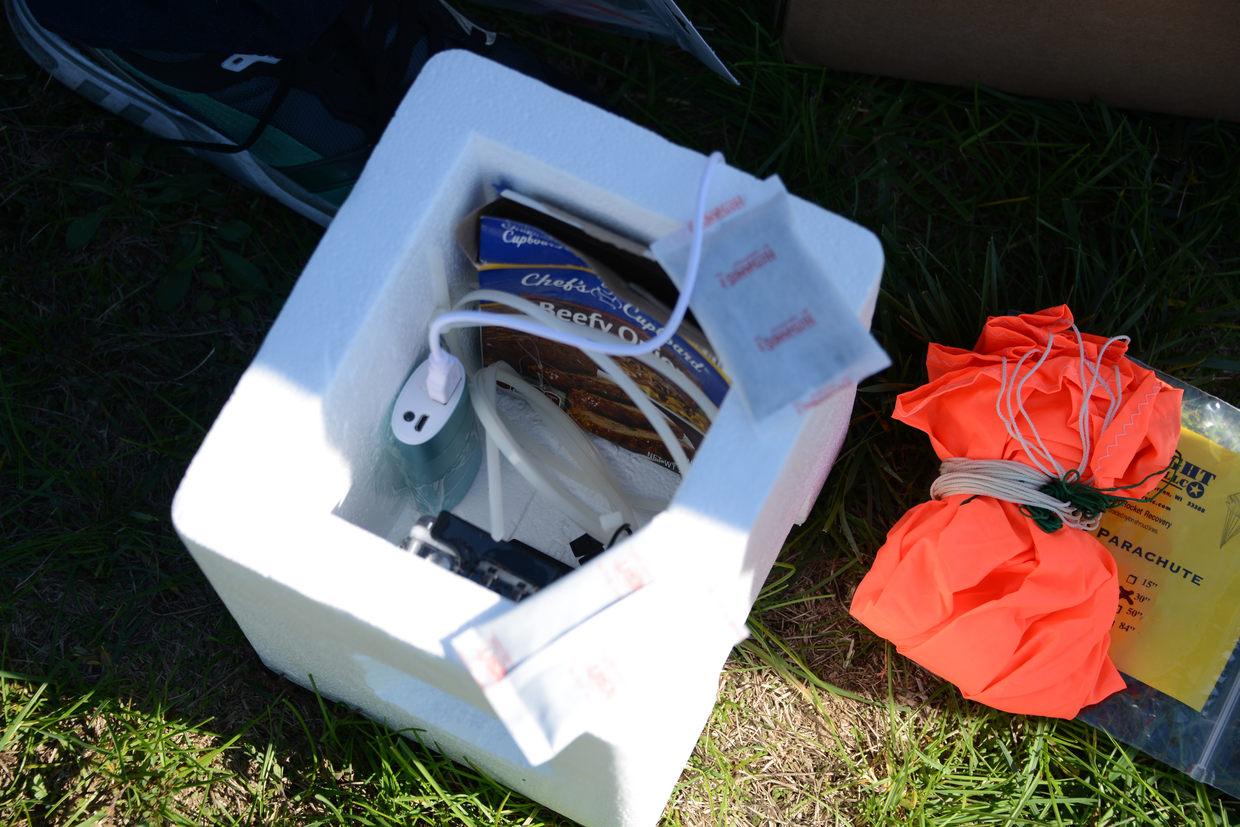
Payload Housing (Styrofoam Cooler)
One Required
This comes as a 2-pack, we couldn’t find a single for sale at a reasonable price
Hand Warmers
We used a single warmer last launch which seemed to work fine. Two on prior launches.
[Update Aug 2016: we actually don't use any hand warmers on well-sealed launches now that use a GoPro. The electronics are sufficiently self-heating, as long as they are not in the direct air-stream on ascent and descent]
Long Zip Ties
Two Required
Key is 36” long zip ties. This is how we attach parachute and hold everything together.
Short Zip Ties
Any bag of small, assorted zip ties will work.
$7
40 feet required
Legally must be 50 pounds or less, we use 40 pound line (the force it breaks at).
40 foot line means if parachute gets snagged in tree the payload should be dangling near the ground

$12
Any USB battery backup will work, we used this on our last flight. This can run our cameras and TM for >6 hours

OR
Top Flight 24” Parachute (PAR-24)
$12
If you have the time we highly recommend checking out the Top Flight parachutes from our friends at
http://topflightrecoveryllc.homestead.com/
Their parachutes are very high quality!
Ground Equipment Recommendations
$60
We developed this after our first launch was a nightmare. Since we started using it we essentially unpack and launch because of this tool. We highly recommend this as it makes everything a lot easier pre-launch. Proceeds go to more research and open-source material
Payload Recommendations
$53
Note: The RioRand is a 720p video. We recommend a
for this.
Recommend GoPro for proper 1080p or 4k resolution and/or a still camera for high resolution still photos
$175
Recommend GoPro for proper 1080p or 4k resolution and/or a still camera for high resolution still photos.
$25
Find a used Canon from eBay -we have used the SD780IS. Make sure to get the appropriate memory card for your camera.
Install Canon Hack Development Kit and run the intervalometer to take periodic images
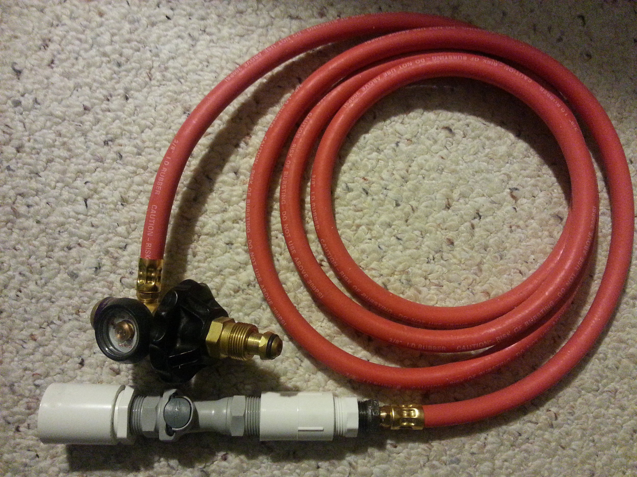
Telemetry Recommendations (more info here)
HUAWEI Fusion 2 U8665 Tracking Cell phone
$50
NOTE: A used GSM or CDMA android phone will work fine as well. Our software (soon to be open-sourced) does require Android version 4.2 or lower (critical function is disabled without root above 4.2)
or
$9
Ting GSM SIM card - No contract, Universal SIM, Nationwide coverage, Only pay for what you use. We have used Ting for all four launches and have been very happy with their service. We typically use around 200 texts for a launch, so the price comes to around $13 including taxes.
$8
Memory Card to store Flight Data Recorder file. Our TM code presently requires a memory card to run. More details in a future post.
NOTE: Our cell phone TM system has only flown a few times. While we are confident in it, if your payload is something you cannot afford to lose we recommend getting a SPOT satellite tracker for telemetry.


We recommend not cutting a hole (such as this picture) in the Styrofoam that goes completely to the inside of the cooler unless you have prior experience or testing to know that your internal electronics won't freeze.
We hope that you find this BOM useful and inspires you to perform your first launch! Again, we welcome feedback from any veterans as we work to make our design less complex, more efficient and less expensive.
Disclaimer, Amazon makes us put this here:
Launch with Us is a participant in the Amazon Services LLC Associates Program, an affiliate advertising program designed to provide a means for sites to earn advertising fees by advertising and linking to amazon.com
It is with great pleasure that we are able to offer our first contribution to the High Altitude Balloon (HAB) Community: our HAB Launch Step-by-Step User guide! Subscribe to our mailing list here to Download your FREE High Altitude Balloon (HAB) user guide
The download is completely Free, and we are open to any and all feedback to make this a more useful resource for fellow HAB enthusiasts. All that we ask to download the free user guide is that you sign up for our mailing list.
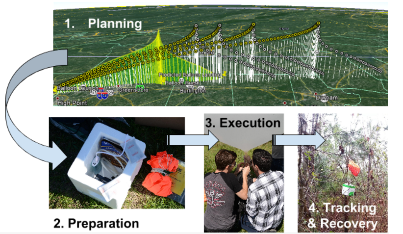
This user guide takes all of our knowledge and lessons from over four launches in the past year and compiles the information in a clear, easy to read format that we are hoping will help many others reach near-space as we have!
In the future, we intend to use the mailing list to contact HAB enthusiasts to get feedback on our user guide and other services, as well as to provide updates on our launches, free services and helpful information, and future products.
We hope that someday our tools and material will allow weather balloon launches to be accessible to anybody, regardless of background. Our approach is to allow people to use a low cost tracker with minimal time invested, and not require that anyone has a HAM radio license or in-depth technical background.
This HAB mailing list is planned to be used for the following purposes:
1) Get in touch with the users of the Instruction Manual to be able to solicit feedback and improve it for future HAB enthusiasts
2) To share news about new releases of the User Guide, our planned open-source tracking software, and other free references for anyone looking to learn more about HAB launches
3) To send information, to those interested, about some of our hardware offerings that were developed (Quick Launch System) that we found simplified the launch process
For mailing frequency, we have not yet determined what the community would find most useful, but we do not foresee anything more often than once a week, and it is likely much less than that (our blog and Twitter are planned to be used for more frequent updates).
Request: If there is anything else that people would like to hear about via our mailing list, we would love the feedback so that this list will add value and we can make near-space more accessible to everyone!
Our promise: Your information will not be shared with any other parties and you will only receive HAB-related updates on a periodic basis from us.
Date: 11 October 2015 Equipment: DS Rev 4
Launch: Fishers Hill, VA
Landing: Luray, VA
Time of Flight: 93 minutes
Distance Travelled: 26 miles
Burst Altitude: (~65,000 ft)
Equipment: DS Rev 4
Launch: Fishers Hill, VA
Landing: Luray, VA
Time of Flight: 93 minutes
Distance Travelled: 26 miles
Burst Altitude: (~65,000 ft)
After the successful launch and recovery of our EFT-3 HAB, we were incredibly eager to put another Dogeship-class weather balloon back into the skies and capture some more stunning photos (and hopefully video) of the Earth. There is something truly awe-inspiring about sending a spacecraft high enough that only a tiny fraction of a percent of ALL of humanity that has ever existed has been able to accomplish a similar feat. We live in a wonderful time of endless technological possibilities and knowledge sharing that makes all of this possible.
One of our goals from the start has been to make this invigorating experience of capturing near-space photos of Earth’s curvature more accessible to those that may not think that it would be even possible: photographers, younger students, and those that have knowledge of perhaps some sub-system of the weather balloon craft but don’t have the skills or confidence that they would be able to pull off all the components that go into a HAB launch.

Enter: EFT-4. Because of all the lessons that we learned throughout the first three launches, we have been assembling a step-by-step user guide that will walk through each of the critical aspects of a HAB Near-Space Weather Balloon launch, and hopefully lead to successful photos and recovery. EFT-4 was our first time letting two complete strangers that have never launched a weather balloon before to try out our user guide, our inflation system, and essentially launch a balloon with minimal guidance from us.

We hope to share our knowledge and help anyone launch a weather balloon, and this user guide is now available for FREE download after signing up for our mailing list here.
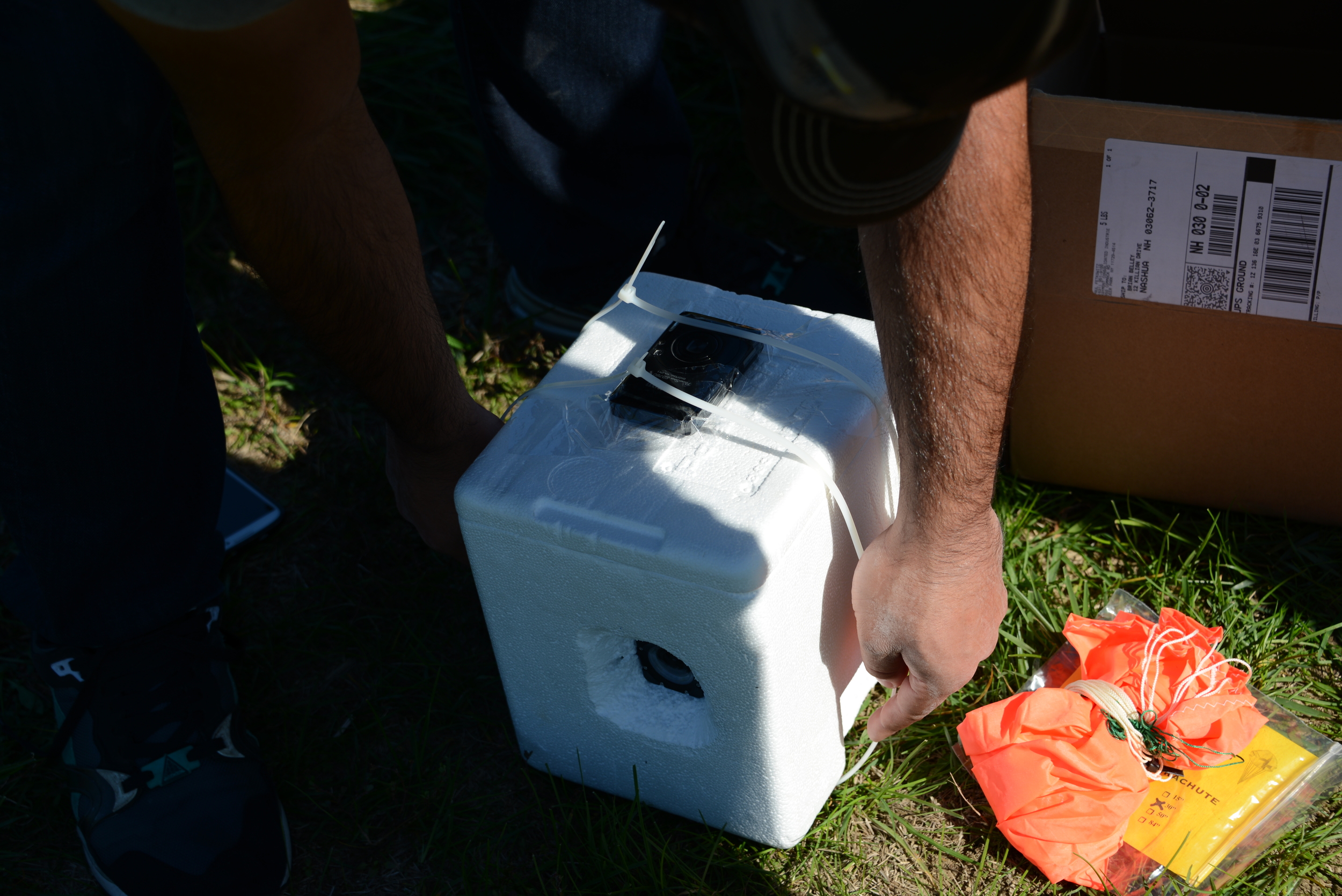
As mentioned in the previous brief overview post of EFT-4, the plan was to flight-test our planned configuration that we had written the user guide around. The only additional component that we included on this flight for data-gathering purposes was our trusty Canon SD 780IS running the CHDK (Canon Hack Development Kit) software to take video on ascent while looking straight up at the balloon.
The details of the flight configuration for predictions of EFT-4 were:
 Payload Weight = 1.79lbs
Nozzle Lift = 6.00 lbs (see an explanation of Nozzle Lift here)
Parachute = 30”
Cameras: 1 RioRand RS4000 (1080p video), 1 Canon SD780IS (720p video)
Parachute to Balloon Length = 60” (one string)
Parachute to Payload Attach = 40’ (one 40lb test string, attached to payload through two zipties)
Payload Weight = 1.79lbs
Nozzle Lift = 6.00 lbs (see an explanation of Nozzle Lift here)
Parachute = 30”
Cameras: 1 RioRand RS4000 (1080p video), 1 Canon SD780IS (720p video)
Parachute to Balloon Length = 60” (one string)
Parachute to Payload Attach = 40’ (one 40lb test string, attached to payload through two zipties)
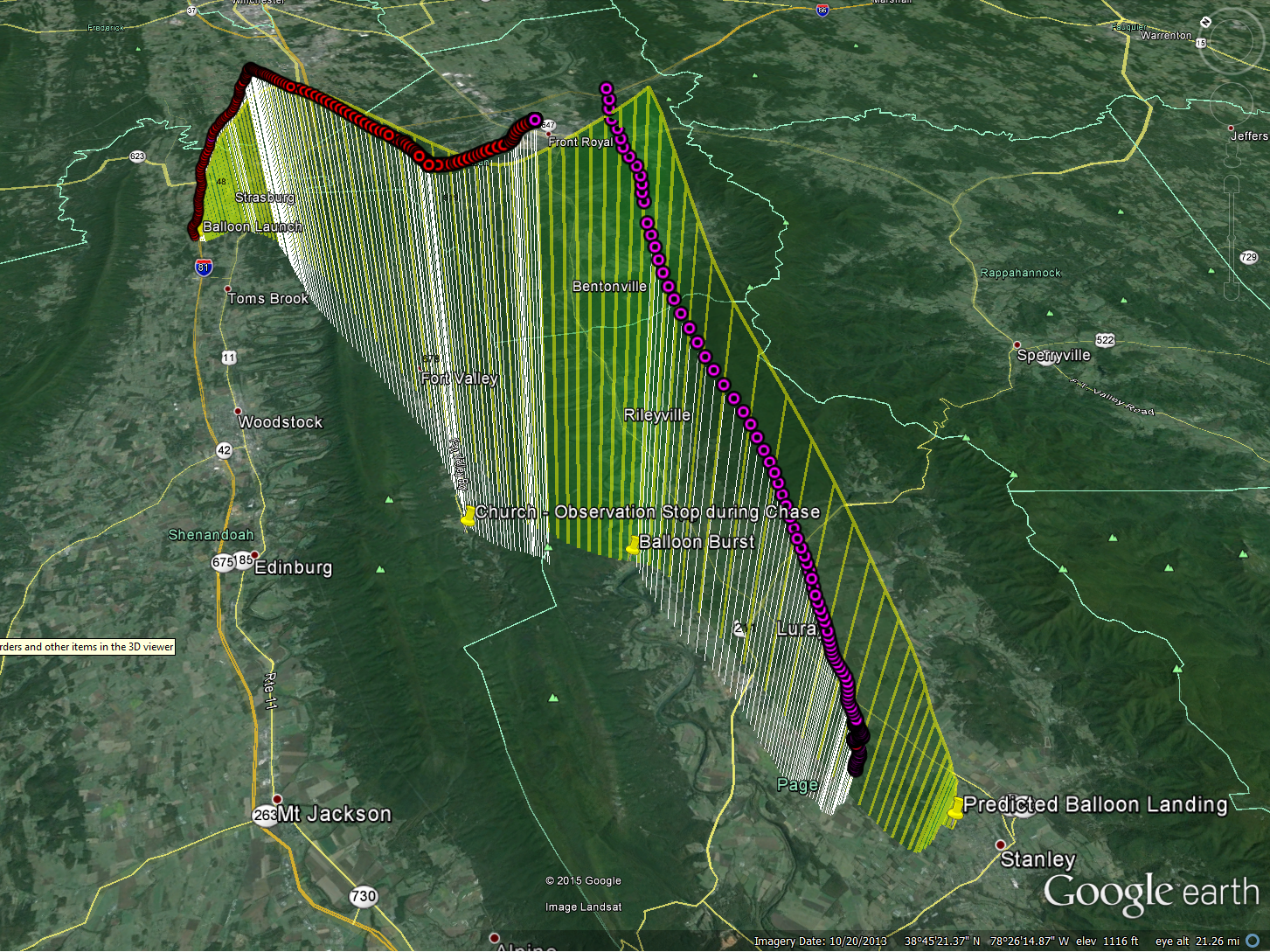
Interestingly enough, the predicted winds on the launch date and time in the Shenandoah valley were southerly, and only expected to carry the balloon roughly 20-30 miles. If we planned it right, we may be able to catch a glimpse of our EFT-4 HAB on descent!
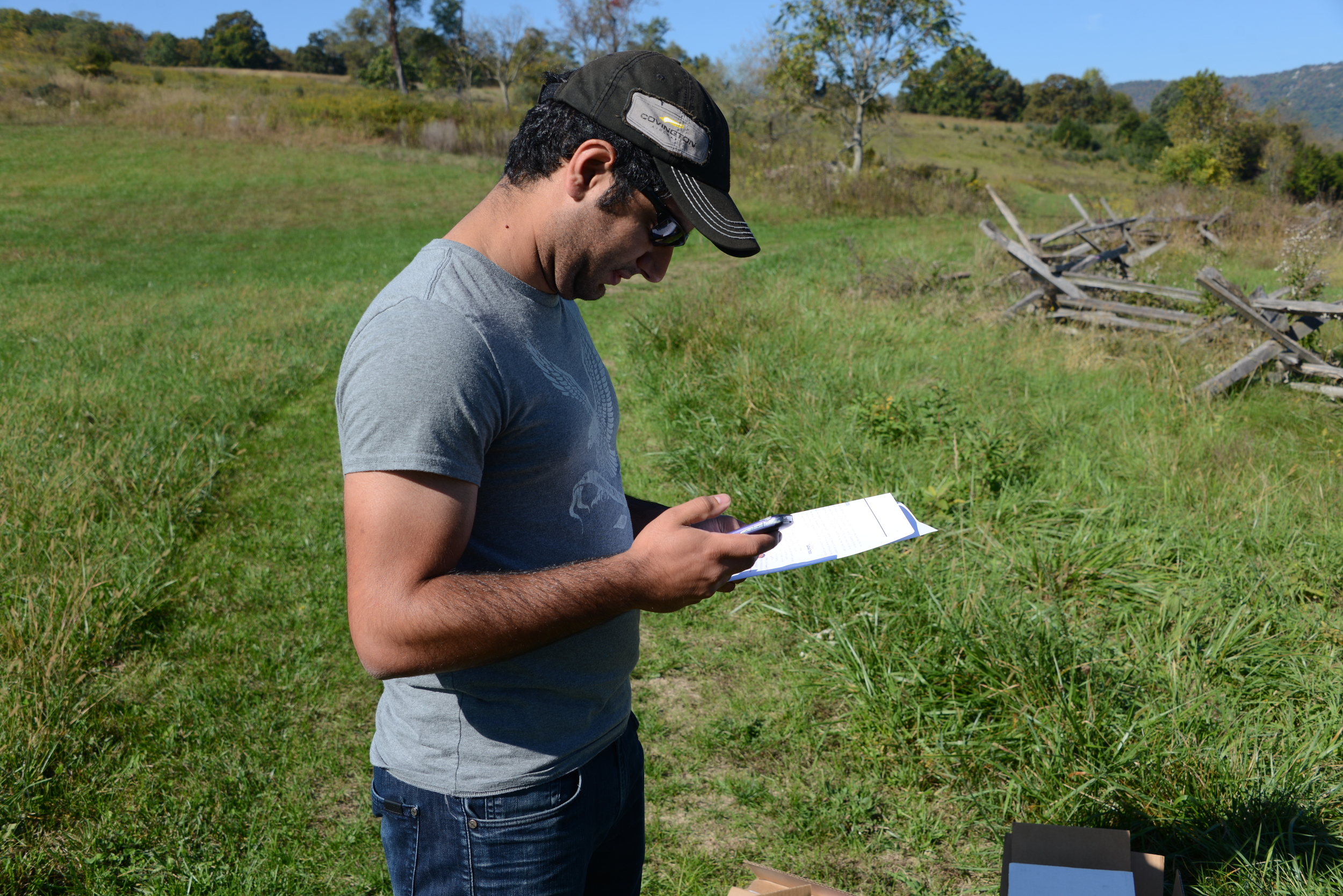 Our guinea pig for the day was Shahin. Although Shahin has an Aerospace background, the entire process of launching a weather balloon was entirely foreign to him. After running our last-minute pre-flight checks and selecting what seemed to be an appropriate launch site (an old Civil War Battlefield), we set out for our destination and prepared to launch.
 Although some questions arose during the process, which was our main intent of having someone unfamiliar run through the steps for launching the HAB, overall the pre-flight preparations ran smoothly. Another friend that had not taken part in a balloon launch before, Billy, had graciously offered to be the paparazzi for the day and captured photos during the entire process.

With the payload prepped, balloon inflated, and all pre-flight checks indicating a GO, Shahin gave the customary launch speech, and away EFT-4 went!
Time of Launch: 12:26PM EST Launch Coordinates: 38.9896069,-78.4169555 (601 Battlefield Rd, Fishers Hill, VA 22645)
Time of Recovery (in-hand): ~2:30PM EST Landing Coordinates:38.6178,-78.5064 (3348 Mill Creek Rd Luray, VA 22835)
0 minutes: Godspeed, Dogeship-4!
https://www.youtube.com/watch?v=qWjSFiQWrAo
2 minutes: Initial SMS messages indicate a nominal ascent rate, in lines with our pre-flight predictions. SMS messages cease (as programmed) once the launch-detect algorithm detects the launch and puts the phone into Airplane mode. We’ll see you on the other side, Dogeship.
5 minutes: Although we’re not receiving communications because of the phone being in Airplane mode, we can still see her! Looking out the moonroof, she is climbing strong (and also rotating pretty violently….).
10 minutes: Based on initial climb and pre-flight predictions, we anticipate possibly being able to drive underneath the point of burst. Although we don’t expect to see her, we figure we will drive to that point along the Shenandoah valley ridge and give it our best shot. Meanwhile, up at 13,000 ft. altitude...
https://www.youtube.com/watch?v=0srqlL6Zt14
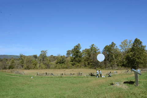
 25 minutes: We arrive at the intersection underneath the expected point of burst, and pull over in a Church parking lot. Again, not expecting to see anything (but still desperately hoping so), we hang out here for roughly 10 minutes. Updated in-flight predictions show that she may actually be going a little more north (towards the left of the Church in the picture), and unfortunately not traveling as far as we originally predicted. We decide to drive slightly north to see if we can scope out the area.
It's around this point in time when both the Riorand Camera and the Canon camera videos stopped. The Riorand froze most likely due to overheating (still powered up upon recovery), while the Canon camera likely froze due to the cold. Here is the entire ~24 minutes of flight looking up from the payload at the balloon. It's a violent flight, so hang on!
https://www.youtube.com/watch?v=17Zqec1P-_g
40 minutes: Landing zone assessment: not optimal at all. Trees everywhere! And worst of all, absolutely no cell phone service. If the updated pre-flight predictions are correct and she ends up landing short along the ridge, it is starting to appear that our chances of recovery (and of even hearing back) are pretty slim.
50 minutes: Because we have no cell service, we decide to drive to the top of the ridge. What a view! The beautiful fall foliage overlooking the valley almost makes us forget about how grim our prospects are starting to look for a successful Dogeship-4 recovery (almost).
60 minutes: With a few bars of service on the top of the ridge, we still haven’t heard anything from our Dogeship. Expecting to have heard back for nearly 10 minutes but not receiving a single text and fearing the worst, we decide to take a hike up the trail on the ridge.

80 minutes: Long past when we expected to receive an SMS and hanging on to what little thread of hope remained for a recovery, we finally get a GPS coordinate message! She just cleared the landing altitude detection threshold...she’ll be on the ground in only a few minutes, and is only a 20 minute drive from us (within 2 miles of where we originally anticipated the landing). Quickly abandoning our hike, we run back to the cars and get underway.
93 minutes: En route to the landing site, EFT-4 touches down. The location is in Luray, VA on a farm, smack in the middle of a field. With enough distance to the nearest tree line, we’re sure we’ll be able to pick her up, so long as someone is around that allows us on to their property.
120 minutes: After approaching the owners of the farm, we walk out to the field, and pick up Dogeship-4. The Canon camera still has the lens out but is obviously frozen in that position and no longer taking pictures, while the RioRand camera appears a bit foggy, but still in-tact. SUCCESS!
After a quick thank-you with the farm owners, we embark back to a surrounding town for some celebration BBQ.
Overall, EFT-4 was a complete success. The balloon ended up landing within 2 miles of the predicted landing zone, we recovered the payload in just over 2 hours after launch, and we got some useful video on ascent. Thank you to Shaheen and Billy for their help on this successful EFT-4 launch!
As with each of our launches thus far, we had a lot of learning and takeaways from this launch. Although we obtained video during ascent, both cameras failed roughly 20 minutes into flight (one overheated, one froze).
Flight Hardware Lessons Learned:
Other Lessons Learned:
